They started it in 2009, so I guess that is why the big plaque(on the right) says 2009, it was just finished in June of 2010?? Hmm
Inside the tunnel are these monoliths, with the recreation of local petroglyphs. Pretty cool!
Three of them in the center.
The top face is called Tsagaglagal "She who watches"
link to the local Native American legend. I would love to go see this in person some time.The rock at the other end of the tunnel, commemorates the people who worked on this project. I know quite a few of them.
Up at the top of the Dike, looking south towards the river, is a viewing platform. So we walked down there.
This is behind us looking back down to the tunnel. Stairs on the left, and the handicapped ramp on the right.
Looking West, the Dike ends about a quarter mile in this direction.
Looking East, the path we will take.
Meanwhile, we walked down to the viewing platform. Looking East again, up river.
Looking West again, there is a fishing dock, the other end leads to a parking lot on this side of the Dike, you have to cross the highway to get to it that way. Here you can possibly catch, sturgeon, small mouth bass, squawfish(there is a bounty on these in the Columbia), starry flounder, salmon, steelhead, carp, and probably a few others, if you can entice them to your hook that is! LOL I have caught all of these just a little farther up river from here, off the bank, and when we had our boat we caught a lot of sturgeon.
Here are some fishermen, one coming down river and one anchored, may be still fishing for some late salmon?? Dont know what is running right now, will have to ask Hubby.
The water in the Columbia River isnt real clear, usually it is a green brown color, full of algae.
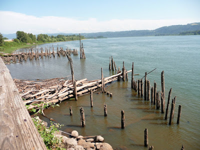
East off of the viewing platform are some old pilings. The water is still really high for this time of year.
And back up at the top again. There have been a few different names for the Park at the middle of the Dike. When I was a kid it was Cottonwood beach, but everyone called it BA beach, yes BA stands for what you think it does! LOL
Now they have renamed the area Captain William Clark Park, after the Lewis and Clark expedition that came through here.
Looking East again, at Mt Hood, beautiful and deadly she is. They still havnt found, four climbers that I know of from the last couple of years, that have gotten lost up there. She is about 40 miles away from us.
That concluded the first part of this post....back tomorrow!!


Such a nice area , I would love that walk.
ReplyDeleteThat looks like such a nice walk- the water and mountains are beautiful! That's a really cool tunnel- I love the patterns and symbols on the rocks.
ReplyDeleteWalk looks like a nice one. Where is it from me? I live in Portland.
ReplyDeleteWilsonc, It is in Washougal, East on Hwy 14 to the 16th st exit, and the first right. The tunnel is right next to Pendleton Woolen Mills outlet here in Washougal. You can walk and then go shopping, he he he he!
ReplyDeleteLooks like a great place to walk and enjoy a beautiful day. I love the petroglyphs in the tunnel. We have a lot of places to enjoy them here in NM, and the ones that they used on those rocks as decorations look very similar. They are also very whimsical and fun, too. :)
ReplyDeleteIt's always interesting to me how those in the PNW love to see their snow covered volcanoes, even with them being so close. To me they look, like you said, deadly, and dangerous, because they are still active. The snow makes them look so quiet, peaceful and pretty, but it's very misleading for an active volcano. So many people live in such close proximity. I hope none of those volcanoes erupt in our lifetime.
~Lisa
Lisa, one of those volcanos has erupted!! I was 13 years old when we watched Mt st Helens erupt, it was pretty scary! I would still rather live on a mt than in the lowlands where it floods! LOL LOL
ReplyDeleteAnd Yeah we love our mtns :0)
Mt HOod has not been "active" occasionally there are earthquakes, but not big enough we have felt them. Geez if she blew! there would be devistation!